Top 10 Hiking Trails in Iceland for Adventure Seekers

Iceland is a hiker’s paradise, where every trail leads through a landscape shaped by fire and ice. From steaming geothermal valleys and colorful rhyolite mountains to dramatic coastal cliffs and glacier-capped peaks, the country offers an astonishing variety of hiking experiences for all levels. Whether you’re seeking a gentle stroll to a hot spring or a challenging trek across volcanic highlands, these top 10 hiking trails showcase the very best of Iceland’s wild and unforgettable nature. Lace up your boots and discover the trails that make Iceland a world-class destination for outdoor adventure.
Here are the top 10 hiking trails in Iceland:
Distance: 10.5 km (round trip)
Elevation Gain: 905 m (starting at 274 m)
Duration: 5–6 hours
Difficulty: Moderate to Challenging
Best Time: June to September
Mount Súlur, the iconic twin-peaked mountain rising southwest of Akureyri, is a beloved symbol of the town and a classic hiking destination for locals and visitors alike. The peaks of Súlur stand sentinel over the “Capital of the North,” their pale rhyolite slopes a striking contrast to the lush valley below.
The most popular route begins at the end of Súluvegur road, where a parking area in Glerárdalur valley marks the start of the adventure. From here, the well-trodden trail leads you steadily upward, first through grassy meadows and then onto the open mountainside. The lower peak, Ytri-Súla, rises closest to town, while the higher, Syðri-Súla, stands at 1,213 meters and offers the ultimate summit experience.
Súlur’s geology is as fascinating as its views. The mountain is composed mostly of light-colored rhyolite, formed by volcanic activity in the ancient Öxnadalseldstöð volcanic system some 8–9 million years ago. As you climb, the landscape shifts from green slopes to rocky ridges, with the town of Akureyri and the shimmering waters of Eyjafjörður growing ever more distant below.
The ascent is steady but manageable for most hikers with a reasonable level of fitness. The round-trip hike covers about 10.5 km and takes 5–6 hours, with an elevation gain of over 900 meters. On clear days, the summit rewards you with breathtaking 360-degree views—across the fjord, over the town, and out to the distant highlands.
Multiple routes are possible, but the most common is from the Glerárdalur parking lot, following the marked path all the way to the top. The trail is free to use, and hikers can enhance their experience with the Wapp hiking app, which provides real-time navigation and information about the route.

Mount Súlur is best hiked from June to September, when the trail is clear of snow and the weather is most favorable. As always in Iceland, be prepared for rapidly changing conditions, and bring sturdy boots, warm layers, and plenty of water.
Whether you’re a seasoned trekker or simply seeking a memorable day above Akureyri, the Súlur hike offers a perfect blend of natural beauty, geological wonder, and panoramic vistas—a true gem of North Iceland.

Distance: 4–10 km (varies by route)
Duration: 2–4 hours
Difficulty: Moderate
Best Time: May to September
Few places on Earth offer the chance to witness the birth of new land, but the Fagradalsfjall Volcano hike on the Reykjanes Peninsula is just such an experience—a living, breathing testament to Iceland’s fiery heart. Since its dramatic eruption in 2021, Fagradalsfjall has become a magnet for adventurers, geologists, and anyone drawn to the raw power of nature.
The hike begins near the parking areas at the end of the winding road from Grindavík, where well-marked trails lead you across a surreal landscape of mossy lava fields and black volcanic sand. The air is tinged with the scent of sulfur, and the ground beneath your boots is still warm in places—a reminder that this is a land in constant transformation.
As you approach the eruption sites, the scenery becomes otherworldly. Jagged rivers of solidified lava snake across the valley, their glossy black surfaces still steaming in the cool Icelandic air. In some years, you may even witness glowing lava flows or the distant rumble of new fissures opening—an awe-inspiring spectacle that draws visitors from around the world.
The main trails—often labeled as Routes A, B, and C—vary in length and difficulty, but all offer unforgettable views of the volcanic craters, fresh lava fields, and the rugged expanse of the Reykjanes Peninsula stretching to the Atlantic horizon. Along the way, you’ll pass viewpoints where you can safely observe the volcanic activity, take in the scale of the eruption, and marvel at the forces that continue to shape Iceland.
Fagradalsfjall is a hike for the senses: the heat radiating from the earth, the hiss of steam vents, the ever-changing colors of cooled lava, and the stark beauty of a landscape reborn. It’s a reminder of Iceland’s restless geology and a rare opportunity to walk where the world is still being made.

Due to the dynamic nature of the volcano, conditions can change rapidly. Always check the latest updates from local authorities before setting out, and follow marked trails and safety guidelines. Bring sturdy footwear, layers for changing weather, and plenty of water—there are no facilities on the trail.
For those who make the journey, hiking Fagradalsfjall is more than a walk through a volcanic valley—it’s a front-row seat to the creation of a new world, and an experience that will linger long after the hike is done.

Distance: Varies (up to 90 km total)
Duration: 1-5 days
Difficulty: Moderate to Challenging
Best Time: June to September
Tucked away in the far-flung Eastfjords, the Víknaslóðir trail network—known as “The Trails of the Inlets”—offers a hiking experience that feels like stepping into a secret world. Centered around the charming fishing village of Borgarfjörður eystri, these trails weave through a landscape of vivid rhyolite peaks, deep green valleys, and secluded coves where the Atlantic meets the wild Icelandic coast.
The Víknaslóðir network is a hiker’s paradise, with routes ranging from gentle day hikes to ambitious multi-day adventures. Trails are well-marked and interconnected, allowing you to tailor your journey to your own pace and interests. Along the way, you’ll pass abandoned farmsteads, silent witnesses to a bygone era, and traverse mountain passes that open onto sweeping views of the fjords and the endless sea.
One of the highlights is the hike to Stórurð (“The Giant Boulders”), a surreal valley filled with turquoise ponds and massive, moss-covered rocks—an otherworldly scene that feels plucked from a fairytale. For those seeking solitude, the remote inlets of Breiðavík, Húsavík, and Loðmundarfjörður offer peaceful campsites and a chance to truly disconnect from the modern world.

Wildlife lovers will delight in the thriving puffin colonies near Borgarfjörður eystri, where thousands of these charismatic birds nest each summer. The area is also rich in folklore, with tales of elves and hidden people woven into the very fabric of the land.
Víknaslóðir is best explored from late June to September, when the trails are clear of snow and the days are long. Whether you’re wandering for a few hours or embarking on a week-long trek, the Trails of the Inlets promise a journey through some of Iceland’s most enchanting and untouched landscapes.
For more information, trail maps, and hut bookings, visit the local information center in Borgarfjörður eystri or Egilstaðir before setting out and check out this article The Víknaslóðir Hiking Trails.
Remember always check the weather forecast and be prepared for rapidly changing conditions in this remote and magical corner of Iceland.

Distance: 4.3 miles (7 km)
Duration: 2-3 hours
Difficulty: Moderate
Best Time: Year-round (weather permitting)
Rising just outside the city limits, Mount Esja is Reykjavík’s beloved backyard mountain—a striking ridge that beckons locals and visitors alike to lace up their boots and head for the heights. The trailhead is easily accessible by car or public transport, making Esja one of the most popular day hikes in Iceland.
The hike begins at the Esjuraetur parking area, where well-marked paths wind their way up the mountain’s flanks. The lower slopes are gentle, meandering through birch groves and wildflower meadows, with the city skyline and Faxaflói Bay gradually unfurling behind you. As you ascend, the trail becomes steeper and rockier, offering a satisfying challenge for those seeking a bit of adventure.
A series of signposts guide you to “Steinn,” a large rock that marks the traditional turnaround point for many hikers. Here, you’re rewarded with sweeping, cinematic views over Reykjavík, the shimmering Atlantic, and—on clear days—the distant Snæfellsjökull glacier. For the more intrepid, the path continues to the summit, where the panorama is even more breathtaking, though the final stretch can be slippery and exposed, especially in winter.

Mount Esja is a hike for all seasons. In summer, the slopes are alive with birdsong and the scent of heather; in winter, the mountain transforms into a snow-dusted wonderland, though crampons and caution are advised. Whether you’re seeking a brisk morning workout or a contemplative afternoon above the city, Esja offers a quintessential Icelandic hiking experience—wild, accessible, and always inspiring.
For more detailed information and a comprehensive guide to hiking the Mount Esja, check out this article Complete Guide to Hiking Mt. Esja.
Remember to check the weather conditions before you set out, and remember to dress in layers to match Iceland’s famously changeable weather.

Distance: 2.5 miles (4 km)
Duration: 2-3 hours
Difficulty: Easy
Best Time: Year-round
The Reykjadalur hiking trail is a popular destination for those looking to experience Iceland’s geothermal wonders up close. This trail, located near the town of Hveragerði, offers a unique opportunity to hike through a valley filled with steaming vents, bubbling mud pots, and hot springs.
The trail is approximately 3 kilometers (1.9 miles) one way and begins at a parking lot just outside Hveragerði. As you start your hike, you’ll cross a bridge over the river Varmá and follow a gravel path that winds through the picturesque Rjúpnabrekkur Ptarmigan slopes. The trail gradually ascends, providing stunning views of the surrounding landscape and the geothermal activity that characterizes the area.
One of the main highlights of the Reykjadalur trail is the natural hot river, where hikers can take a relaxing dip in the warm waters. The river’s temperature ranges from 38 to 40°C (100 to 104°F), making it the perfect spot to unwind after a hike. The hot baths in the river are a popular attraction, and there are wooden walkways and changing facilities to make the experience more comfortable.

The hike to Reykjadalur is suitable for hikers of all levels and typically takes about 45-60 minutes one way, with plenty of opportunities to stop and take photos along the way. The trail is best hiked from May to September, and it is recommended to bring swimwear and towels if you plan to enjoy the hot river.
For more detailed information and a comprehensive guide to hiking the Reykjadalur trail, check out this article Reykjadalur hot springs on GoNow.

Distance: 12 miles (20 km) round trip
Duration: 10-15 hours
Difficulty: Very Difficult
Best Time: May to September
The Hvannadalshnúkur hike is an exhilarating adventure that takes you to the highest peak in Iceland, standing at 2,110 meters (6,923 feet) above sea level. Located in the Skaftafell area of Vatnajökull National Park, this challenging trail offers hikers a unique opportunity to experience the stunning beauty of Iceland’s glaciers and volcanic landscapes.
The hike begins at the Skaftafell Visitor Center, where you can gather information and prepare for the journey ahead. The trail spans approximately 22 kilometers (13.7 miles) round trip and typically takes between 10 to 15 hours to complete. As you ascend, you’ll traverse the Öræfajökull glacier, which is part of the larger Vatnajökull ice cap, the largest glacier in Europe.
Along the way, you’ll encounter breathtaking views of the surrounding mountains, ice formations, and the vast expanse of the glacier. The trail is marked by several key landmarks, including the Hvannadalshnúkur summit, which offers panoramic views of the entire region. On a clear day, you can see all the way to the south coast of Iceland and the North Atlantic Ocean.

The Hvannadalshnúkur hike is a demanding trek that requires proper equipment, including crampons and ice axes, as well as a good level of physical fitness. It is highly recommended to undertake this hike with a certified guide, as the glacier can be treacherous and weather conditions can change rapidly.
For more detailed information and guide to hiking Hvannadalshnúkur check out Hvannadalshnukur on SummitPost.

4. Kerlingarfjöll Geothermal Area
Distance: 7 miles (11.5 km) round trip
Duration: 4-5 hours
Difficulty: Moderate
Best Time: Mid-June to early September
The Kerlingarfjöll hiking trails offer an extraordinary adventure through one of Iceland’s most stunning geothermal areas. Located in the central highlands, these trails provide a unique opportunity to explore the vibrant and colorful landscapes of Kerlingarfjöll, known for its striking rhyolite mountains and geothermal activity.
The main trail in Kerlingarfjöll is the Hveradalir geothermal area hike, which spans approximately 11.5 kilometers (7 miles) round trip
This trail takes you through the heart of the geothermal area, where you can witness bubbling mud pots, steaming vents, and hot springs. The hike starts at the Kerlingarfjöll Mountain Resort and follows a zig-zagging path up into the mountains, offering breathtaking views of the surrounding landscape.
Another notable trail is the Kerlingarfjöll Hot Spring hike, which is a shorter but equally rewarding trek. This hike leads you to a natural hot spring where you can relax and soak in the warm waters while enjoying the stunning scenery. The trail is about 3 kilometers (1.9 miles) long and is suitable for hikers of all levels.

For those seeking a more challenging adventure, the Snækollur hike is a must-try. This trail takes you to the summit of Snækollur, the highest peak in the Kerlingarfjöll Mountains, offering panoramic views of both the south and north coasts of Iceland on a clear day. The hike is approximately 5 kilometers (3.1 miles) long and involves a steep ascent along a rocky mountain ridge.
Kerlingarfjöll also offers several other trails, including the Highland Base to Hveradalir hike, the Hverabotn hike, and the Skeljafell hike, each providing unique perspectives of the area’s diverse landscapes. Whether you’re looking for a short day hike or a multi-day trekking adventure, Kerlingarfjöll has something to offer for every hiker.
For more detailed information and a comprehensive guide to hiking in Kerlingarfjöll, check out Kerlingarfjöll Guide in 2025 on Epic Iceland.

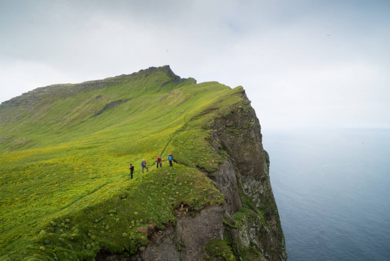
3. Hornstrandir Nature Reserve
Distance: Varies (e.g., Hesteyri to Hlöðuvík is 9 miles/15 km)
Duration: Multi-day hikes
Difficulty: Moderate
Best Time: Summer (accessible by boat)
The Hornstrandir Nature Reserve is a remote and pristine wilderness area in the Westfjords of Iceland, offering some of the most breathtaking and untouched landscapes for hiking enthusiasts. The trail from Norðurfjörður to Horn is a journey through rugged terrain, dramatic cliffs, and serene fjords, making it a truly unforgettable experience.
Starting in Norðurfjörður, hikers embark on a journey that takes them through the heart of Hornstrandir. The trail stretches approximately 25 kilometers (15.5 miles) and is known for its challenging yet rewarding path. As you hike, you’ll pass through lush valleys, cross mountain passes, and encounter stunning views of the surrounding fjords and the Arctic Ocean.
One of the highlights of this trail is the Hornbjarg cliffs, which are among the most striking and beautiful in Iceland. These cliffs are home to a variety of seabirds, and the views from the top are simply breathtaking. The trail also takes you through the remote and picturesque Hornvík bay, where you can camp and enjoy the tranquility of the untouched nature.
The journey concludes at Horn, a dramatic headland that offers panoramic views of the surrounding landscape. This area is known for its rugged beauty and is a perfect spot to reflect on the incredible journey you’ve just completed.
Hiking in Hornstrandir requires careful planning and preparation, as the area is remote and weather conditions can be unpredictable. However, for those willing to put in the effort, the rewards are immense. The Hornstrandir Nature Reserve offers a unique opportunity to experience Iceland’s wild and untouched beauty, making it a must-visit for any serious hiker.
For more detailed information and a comprehensive guide to hiking in Hornstrandir, check out this article on Lonely Planet The ultimate guide to Hornstrandir, Europe’s last wilderness.

2. Fimmvörðuháls Trail
Distance: 16 miles (25.7 km)
Duration: 1-2 days
Difficulty: Difficult
Best Time: Mid-June to September
The Fimmvörðuháls Trail is another spectacular hiking route in Iceland, renowned for its breathtaking scenery and diverse landscapes. This trail spans approximately 25 kilometers (15.5 miles) and begins at the iconic Skógafoss waterfall.
Starting at Skógafoss, one of Iceland’s most famous waterfalls, hikers are immediately greeted by the powerful cascade and lush green surroundings. The trail then follows the Skógá River, passing by 26 more waterfalls, each offering its own unique beauty. As you ascend, the landscape transitions from verdant greenery to a more barren, rocky terrain as you approach the ice caps.
The trail takes you between the glaciers Eyjafjallajökull and Mýrdalsjökull, traversing fresh, black volcanic soil, which is among the youngest landscapes on the planet. This section of the hike is particularly striking, with the contrast between the black soil and the surrounding ice caps creating a dramatic visual effect.


The Fimmvörðuháls Trail is a challenging hike, with a total elevation gain of 1,400 meters (4,600 feet) and typically takes between 8 to 10 hours to complete. It is best hiked from mid-June to September, and it is recommended to have proper equipment and possibly a guide if hiking outside of this season.
Whether you’re an experienced hiker or simply looking for an adventure, the Fimmvörðuháls Trail offers an unforgettable journey through some of Iceland’s most diverse and beautiful landscapes.
As you descend into Þórsmörk, the scenery changes once again. The black soil is covered with lime green moss, and eventually, you will hike through a forest before arriving at the Básar Hut in Þórsmörk[1]. This valley, named after the Norse god Thor, is surrounded by glaciers and offers stunning views of the Krossá river.
For more detailed information and a comprehensive guide to hiking the Fimmvörðuháls Trail, check out The Fimmvörðuháls Hiking Trail | Photos and Tips by Guide to Iceland.

1. Laugavegur Trail
Distance: 34 miles (55 km)
Duration: 4-6 days
Difficulty: Moderate to Difficult
Best Time: Mid-June to September
The Laugavegur Trail is a must-visit for any hiking enthusiast exploring Iceland. This iconic trail stretches approximately 55 kilometers (34 miles) between Landmannalaugar and Þórsmörk.
Starting in Landmannalaugar, known for its vibrant rhyolite mountains and geothermal hot springs, hikers are treated to a colorful and unique landscape. The trail then leads through the highlands, offering views of rugged mountains, expansive glaciers, and lush valleys. Along the way, you’ll pass through notable stops such as Hrafntinnusker, Álftavatn, and Botnar, where you can rest in mountain huts that provide basic amenities like heating and sometimes electricity and hot water.

Whether you’re an experienced hiker or a nature lover, the Laugavegur Trail offers an unforgettable adventure through some of Iceland’s most spectacular landscapes. As an off-road hiking trail, it provides a rugged and immersive experience, taking you through diverse terrains that are both challenging and rewarding.
These hiking destinations offer a diverse range of landscapes and experiences, from hot springs to glaciers, rugged wilderness to scenic views. Iceland has something for every hiker, from easy day hikes to challenging multi-day treks. Remember that some of these hikes can be demanding and weather can change quickly, always check the forecast and bring appropriate gear. And it’s also important to stay on designated trails to avoid any damage to the fragile environment.
The journey concludes in Þórsmörk, a stunning valley named after the Norse god Thor. This area is surrounded by glaciers, including Eyjafjallajökull, Mýrdalsjökull, and Tindfjallajökull, and features the breathtaking Krossá river. The entire trek typically takes 4 to 5 days, with daily hikes of about 14 kilometers (roughly 8.5 miles), allowing plenty of time to soak in the incredible scenery and take memorable photos.
For more detailed information and a comprehensive guide to hiking the Laugavegur Trail, check out the official Laugavegur Trail Guide or either of these guides: The The Complete Travel Guide to the Laugavegur Trail or A Guide to Hiking The Laugavegur Trail.

| 🛖 Hut | 🌄 Description | 📏 From Previous | 📍 To Next | ⏱️ Duration | ⚠️ Difficulty |
|---|---|---|---|---|---|
| Landmannalaugar | Geothermal wonderland with colorful rhyolite mountains and hot springs. | — | 12 km to Hrafntinnusker | 4–5 hrs | Moderate (steep ascent, variable weather) |
| Hrafntinnusker | High-altitude hut often surrounded by snow, with panoramic views. | 12 km | 12 km to Álftavatn | 4–5 hrs | Moderate to Challenging (snow, river crossings) |
| Álftavatn | Lakeside hut in a scenic green valley, ideal for rest. | 12 km | 1.5 km to Hvanngil or 15 km to Emstrur | 4–6 hrs | Moderate (steep descent, rivers) |
| Hvanngil | Peaceful hut in a lava field valley, often used as an alternative to Álftavatn. | 1.5 km | 13.5 km to Emstrur | 4–5 hrs | Moderate (wind exposure, rough terrain) |
| Emstrur (Botnar) | Surrounded by black sand deserts and canyons, with glacier views. | 15 km (from Álftavatn) or 13.5 km (from Hvanngil) | 15 km to Langidalur or Básar | 5–6 hrs | Moderate (longer day, exposed terrain) |
| Langidalur | Main hut in Þórsmörk, surrounded by birch woods and dramatic mountain scenery. Popular endpoint for Laugavegur. | 15 km from Emstrur | 2 km to Básar (optional extension) | 6–7 hrs | Moderate (river crossings, varied terrain) |
| Básar | Large hut complex in Þórsmörk, nestled in a sheltered valley with great access to local trails. | 2 km from Langidalur or 15 km from Emstrur (direct) | — (end of Laugavegur, or continue Fimmvörðuháls) | 0.5–1 hr from Langidalur | Easy (well-marked, short distance) |